|
 Curently online :
51 Curently online :
51 |
|
 Total visitors :
7672422 Total visitors :
7672422 |
|
|
`Data streaming from the spectrometer`: a new dawn for soil assessments
Wednesday, 2020/08/19 | 08:35:00
|
|
World Agroforestry – August 13 2020
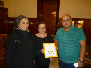
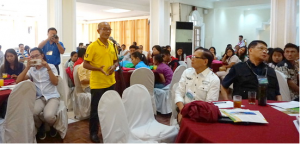
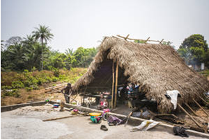
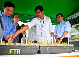
Figure: Elvis Weullow of the ICRAF Soil and Plant Spectroscopy Lab demonstrating how to use the Alpha Spectrometer. Photo: World Agroforestry/Ann Wavinya
For over two decades, the Soils Theme of World Agroforestry (ICRAF) in collaboration with partners has been at the cutting edge globally of innovations in soil spectroscopy, creating a large planetary database of soil data, which plays an important role in agricultural research and ecosystem restoration.
World Agroforestry (ICRAF) has been leading advances in soil spectroscopy springing from the conversion of its standard wet chemistry soil laboratory into a Soil–Plant Spectral Diagnostics Laboratory in 2000. This laboratory uses only light to measure the properties of soil rather than expensive and time-consuming chemical processes. Thanks to the rapidity of estimation provided by spectroscopy in the infrared part of the spectrum, the lab produces large volumes of spectral data daily.
The soil spectral library developed by ICRAF has a range of uses, from agricultural research to applications in ecology and ecosystem restoration. Because each soil spectral measurement allows for the prediction of multiple soil properties simultaneously, rapid assessments can be made at low cost.
‘Because ICRAF combines systematic collection of field data, using the Land Degradation Surveillance Framework (LDSF) with soil spectroscopy, we now host the largest systematic, georeferenced library of soil infrared spectra in the world,’ said Leigh Ann Winowiecki, soil scientist and leader of the Soils Theme at ICRAF. ‘This creates opportunities for robust baseline assessments of key indicators of soil health at the accuracy and scale needed for land managers and for tracking the performance of indicators over time.’
Over the last two decades, the lab has worked with multiple partners, ranging from research organizations and governments through private companies to academic centres of excellence. For example, phase one of the Africa Soil Information Service (AfSIS) project, funded by the Bill and Melinda Gates Foundation, provided a consistent baseline of soil information for monitoring the health of soil in Sub-Saharan Africa using the LDSF and soil spectroscopy. Partners included World Soil Information (ISRIC), Tropical Soil Biology and Fertility of the International Center for Tropical Agriculture, Center for International Earth Science Information Network of the The Earth Institute at Columbia University.
ICRAF is one of the founding members of the Global Soil Laboratory Network, established within the framework of the Food and Agriculture Organization of the United Nations and the Global Soil Partnership (GSP). One of the key outcomes of the intiative is the development of a global soil spectral calibration library to better understand soil condition.
In AfSIS, we randomized a set of 60 LDSF sites based on Köppen–Geiger climate zones across sub-Saharan Africa,’ explained Tor-Gunnar Vågen, who is head of the Spatial Data Science and Applied Learning Lab at ICRAF. ‘This provided a unique opportunity to assess soil and land health at various scales across the sub-continent, overcoming the problem of bias in past soil sampling.’
As a result, over 18,500 soil samples were collected using the Framework from 19 African countries and analyzed using mid-infrared spectroscopy. ‘It was a great development and learning opportunity for the lab,’ highlights Elvis Weullow, the ICRAF Soil lab manager. ‘We dedicated a lot of time and effort to develop and put in place robust systems to handle such enormous numbers of samples, with stringent quality control process in all our workflows right from sample reception, analysis and data processing. We had great teamwork, which contributed to the successful implementation of project deliverables.’
‘It was great teamwork, which involved tracking samples from the field into the lab,’ echoes Andrew Sila, data scientist with the Soils Theme. ‘When the data started streaming from spectrometers, it was a new dawn for the team, which meant developing robust workflows for processing the spectral data and translating it into understandable formats. The process involved a combination of open source technologies — mainly for data wrangling — which evolved into standardized data workflows.’
In line with the CGIAR’s Open Access Open Data policy, the 18,500 soil spectra collected during phase one of the Africa Soil Information Service project have been uploaded on the World Agroforestry Research Data Repository, where they are accessible to both researchers and the public.
According to the CGIAR’S Platform for Big Data in Agriculture, data have become valuable global commodities. Data is much more than simply information. For example, through the development of the advanced analytic capabilities at ICRAF, soil spectra can be applied in the true sense of ‘big data, allowing challenges in agricultural development to be solved faster, better and at a greater scale than before’.
The Open Access policy improves the speed, efficiency and efficacy of research, also enabling interdisciplinarity, allowing the global public to benefit even more from CGIAR research.
‘Publishing data on the ICRAF Dataverse has enormous and limitless benefits for our researchers and also to society in general,’ said Joshua Moreto, a data scientist with the Research Methods Group at ICRAF who manages the dataverse projects. ‘Our centre research data repository makes data discoverable to any internet user through a structured description commonly known as metadata.
The repository stores data for a long time, which promotes re-use, cost-effectivity and value-adding to present and future research. At the top of the benefits is making our scientists’ research open for potential collaboration with other researchers and governments, other research institutions and humanitarian and development organizations.’
‘Soil spectroscopy has really advanced the field of landscape monitoring, enabling landscape-wide assessments of key indicators soil and land health in a timely, efficient and cost-effective manner,’ said Winowiecki.
|
|
|
|
[ Other News ]___________________________________________________
|
(89).png "`Data streaming from the spectrometer`: a new dawn for soil assessments")